Thorang Peak is ideal for those who have some mountaineering experience and are ready to challenge themselves on a less-commercialized route. The climb offers panoramic views of the Annapurna and Dhaulagiri ranges, as well as close-ups of nearby peaks like Yakawa Kang, Khatung Kang, and the Gangapurna ridge.
In this 2026 guide, you’ll find a complete breakdown of everything needed to plan a successful climb to Thorang Peak — including permits, difficulty, gear list, training, route, safety, and cultural context.
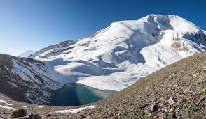
Location and Geography
Thorang Peak is located in the Manang district of north-central Nepal, close to the border with Mustang. The peak is positioned just above the well-known Thorong La Pass, one of the highest trekking passes in the world, and part of the Annapurna Conservation Area (ACA) — Nepal’s largest protected area.
Geographically, Thorang Peak lies between the Annapurna and Dhaulagiri ranges, providing commanding views of snow-capped summits, glacial valleys, and ancient Tibetan-style villages. The trail to the peak traverses multiple ecological zones — from rhododendron forests and subalpine meadows to high-altitude tundra and barren scree fields.
Significance and Recognition
Though less popular than Island Peak or Mera Peak, Thorang Peak offers solitude and a deeper sense of wilderness. Its location on the Annapurna Circuit, near Thorong La, makes it accessible yet less frequently climbed due to its more demanding nature.
First climbed by local climbers and trekking groups in the 1980s, it was later classified as a Group “B” trekking peak by the Nepal Mountaineering Association (NMA). It remains one of the region’s hidden gems for those seeking an off-the-beaten-path mountaineering challenge.
Permits and Fees (2026)
To climb Thorang Peak, the following permits are mandatory:
1. Thorang Peak Climbing Permit (NMA Group B Peak)
-
Issued by the Nepal Mountaineering Association (NMA).
-
Cost varies by season:
-
Spring (Mar–May): USD 250 per person
-
Autumn (Sep–Nov): USD 125 per person
-
Winter/Summer (Dec–Feb, Jun–Aug): USD 70 per person
-
2. Annapurna Conservation Area Permit (ACAP)
-
Required for entering the Annapurna region.
-
Cost: NPR 3,000 (approx. USD 25) for foreign nationals.
3. Trekkers’ Information Management System (TIMS) Card
-
Required for safety and registration.
-
Cost: USD 20 (through trekking agencies), or USD 10 (group travelers).
Permits can be arranged by a licensed trekking agency or acquired independently in Kathmandu or Pokhara.
Best Time to Climb Thorang Peak
1. Spring (March–May)
-
Advantages: Stable weather, excellent visibility, moderate temperatures, fewer weather-related delays.
-
Disadvantages: Slightly more crowded on the Annapurna Circuit.
2. Autumn (Late September–November)
-
Advantages: Clear skies, crisp air, ideal for photography, dry trails.
-
Disadvantages: Cold nights; trail traffic increases post-monsoon.
3. Winter (December–February)
-
Advantages: Fewer trekkers, peaceful routes.
-
Disadvantages: Heavy snow, extreme cold, increased risk of storms and avalanches.
4. Monsoon (June–August)
-
Not recommended. Trails are slippery, high landslide risk, and peak may be inaccessible.
Difficulty and Technical Grade
Overall Difficulty: Moderate tAltitude: 6,144 meters –
High altitude requiring acclimatization.
-
Technical Grade: PD+ to AD- (Peu Difficile/Assez Difficile – slightly to moderately difficult)
-
Terrain:
-
Glacier crossings
-
Snow and ice slopes (30°–45°)
-
Mixed climbing on snow, scree, and loose rock
-
Skills Required
-
Basic to intermediate mountaineering experience
-
Knowledge of crampon use, ice axe handling, rope work, and glacier navigation
-
Comfortable ascending steep snow slopes and using fixed ropes
Route Description
Approach via the Annapurna Circuit
The climb begins on the Annapurna Circuit, starting from Besisahar or Jagat, ascending through:
-
Chame (2,670m) – a key hub with warm springs
-
Manang (3,540m) – the acclimatization center
-
Yak Kharka (4,110m) – pasturelands with few teahouses
-
Thorong Phedi (4,540m) or High Camp (4,880m) – final teahouses before the pass
At Thorong High Camp, climbers diverge from the main trail leading to the Thorong La Pass and move toward the base of Thorang Peak, often setting up a temporary High Camp around 5,100m.
Climbing Route to Summit
-
Base to High Camp: Involves ascending through scree and mixed terrain.
-
High Camp to Summit:
-
Pre-dawn start (1:00–3:00 AM)
-
Traverse snow slopes with occasional crevasses
-
Steep final slope may require fixed rope
-
Ridge walk to the summit with panoramic views of Annapurna II, IV, Gangapurna, Dhaulagiri, Tilicho, and Yakawa Kang
-
Descent is via the same route, either to High Camp or directly back to Thorong Phedi.
Acclimatization Strategy
Key acclimatization points:
-
Manang (3,540m) – Spend at least 2 nights
-
Yak Kharka (4,110m) – 1 night to prepare for high altitudes
-
Thorong High Camp (4,880m) – 1–2 nights to prepare for summit push
Include acclimatization hikes to Ice Lake (4,600m) or Tilicho Lake (4,919m) if time allows.
Training and Preparation
Physical Training (Begin 3–6 Months Before)
-
Cardio: Hiking, running, stair climbing
-
Strength: Focus on legs, core, and shoulders
-
Endurance: Long-distance hikes with weighted backpack
Technical Training
-
Take an introductory mountaineering course if you lack experience.
-
Practice with:
-
Ice axe and crampon use
-
Fixed line climbing
-
Glacier rescue techniques
-
Essential Gear List
Personal Gear
-
Down jacket (-20°C)
-
Waterproof shell jacket and pants
-
Insulated gloves and mittens
-
Wool or synthetic base layers
-
Mountaineering boots (insulated)
-
Thermal hat and balaclava
-
UV-protection sunglasses
Climbing Equipment
-
Harness
-
Helmet
-
Ice axe
-
Crampons
-
Carabiners (locking and non-locking)
-
Jumar and belay device
-
Static/dynamic rope (provided by agency)
Camping and Miscellaneous
-
4-season sleeping bag (-20°C or below)
-
Trekking poles
-
Headlamp with extra batteries
-
Hydration bladder and water bottles
-
Personal first aid kit
-
Altimeter or GPS watch (optional)
Safety and Emergency Protocols
Common Hazards
-
AMS (Acute Mountain Sickness)
-
Frostbite
-
Avalanches and falling rock
-
Crevasses and whiteouts
Prevention and Response
-
Acclimatize slowly
-
Always climb with a guide or rope team
-
Use satellite phones or radio for emergency communication
-
Helicopter evacuation insurance is essential (rescue costs can exceed $5,000 USD)
Cultural Experience
The trek passes through diverse ethnic villages of the Gurung, Thakali, and Manangi people.
-
Manang: Rich in Tibetan Buddhist culture, monasteries, and festivals like Yartung and Losar.
-
Braga Monastery: A 600-year-old spiritual site.
-
Local foods: Dal Bhat, tsampa, yak cheese, thukpa.
Respect customs by:
-
Walking clockwise around stupas
-
Avoiding pointing feet at religious objects
-
Using the phrase “Namaste” to greet locals
Environmental Responsibility
Thorang Peak lies within the Annapurna Conservation Area, so climbers must:
-
Use reusable water bottles (avoid plastic)
-
Pack out all waste
-
Avoid disturbing wildlife and flora
-
Stick to established trails
Many trekking agencies are eco-certified, offering sustainable climbs with trained porters and guides.
Tips for a Successful Thorang Peak Climb
-
Hire an experienced guide: Especially for navigating glacier sections and ensuring safety.
-
Don’t skip acclimatization days: AMS can derail your entire trip.
-
Use weather windows: Summit early in the morning for best conditions.
-
Stay hydrated: Dehydration worsens altitude symptoms.
-
Check your insurance: Ensure it includes high-altitude trekking and helicopter evacuation.
- Layer smartly: Weather can change rapidly above 5,000m


